

























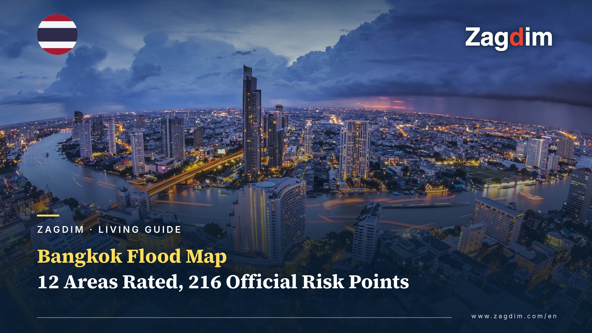
The Bangkok Flood of 24–26 September 2026: All 50 Districts Declared Disaster Zones, and What It Means for Where You Live
The Bangkok flood of 24–26 September 2026 was a rainwater flood, not river overflow: according to the Bangkok Metropolitan Administration’s (BMA) own 2026 flood plan, the drainage system copes with no more than 80 mm of rain a day, and five city rain stations logged more than 200 mm in 24 hours, according to BMA station data reported by Thai media. Heavy rain began on the afternoon of Thursday 24 September and lasted about 48 hours. According to Thai media reports of the Bangkok governor’s press conference, some areas received around 300 mm from Thursday afternoon onwards, comparable to the 1983 rains. The BMA first declared three districts disaster zones (Nong Chok, Suan Luang and Khan Na Yao). On 26 September the governor signed an announcement extending this to all 50 districts, backdated to 25 September. The declaration allows district offices to provide relief under their own powers; it does not mean every household automatically receives assistance.
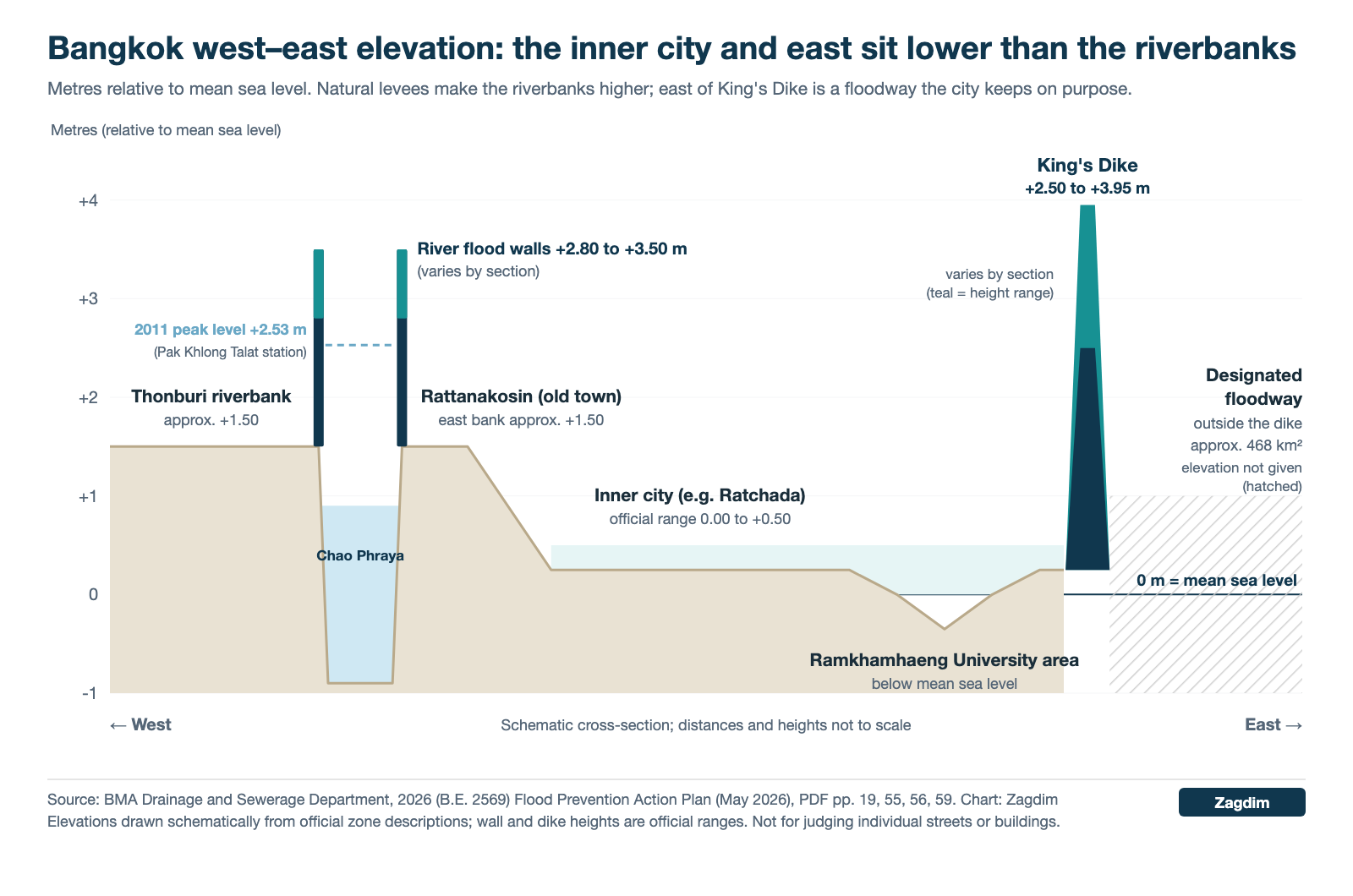
If you are about to sign a Bangkok lease or buy a condo, the useful question is not how bad this week was, but how flood-prone a given neighbourhood and building are. The first layer of the answer is ground height and flood defences. The BMA Drainage and Sewerage Department’s 2026 (B.E. 2569) Flood Prevention Action Plan, published in May 2026, puts land along the Chao Phraya River at about 1.5 m above mean sea level, while the inner city, the east and the south sit only 0 to 0.5 m above it. As a result, riverbank land inside the flood walls, and inner-city districts inside King’s Dike (the eastern flood embankment) that stayed dry in 2011, show fewer public warning signs. That is an area-level comparison: within one district, the soi (side street), the car park and the floor you live on still make a difference.
This guide rates 12 areas where expats commonly rent and buy, explains what each rating is based on, gives a building checklist for renters and buyers, and lists 11 condominiums that meet a set of public criteria.
Key Points
- Who needs to take note: expats looking for a rental in Bangkok, foreign buyers comparing condos across Bangkok districts, and owners of Bangkok property who want to reassess.
- There are two kinds of Bangkok flood. The 24–26 September 2026 event was a rainwater flood, where drainage could not keep up. The other kind is river and tidal flooding in October to December, which affects land outside the river flood walls and outside King’s Dike. Look at the two separately.
- Zagdim compared 12 areas popular with foreign residents (with the riverside split into east and west banks) using five sets of public data, and sorted them into three tiers: recommended, consider with inspection, and extra caution. We also list 11 condominiums that meet public criteria.
- What matters most is not the district name but the soi, whether the car park is below ground, the access road and the floor. Finding no flood reports for a building does not mean it has never flooded, and does not mean it will not flood in future.
Two Kinds of Bangkok Flood: Rainwater in the Wet Season, River and Tide From October to December

The seasons below are drawn from the BMA’s 2026 flood plan, PDF pp. 18–22:
| Type | Peak period | Main areas affected | What it means when choosing a home |
|---|---|---|---|
| Rainwater flooding (the 24–26 September 2026 event) | Wet season May–October, heaviest from mid-August to mid-October | Low-lying, slow-draining sois in the inner city and east, and low points on main roads | Check how low the soi is, main-road risk points, and whether the car park is underground |
| River and tidal flooding | Water from the north peaks in October–November; tides peak October–December | Riverside communities outside the Chao Phraya flood walls, gaps in the walls, and the floodway outside King’s Dike | By the river, confirm the building is inside the flood wall; outside King’s Dike, take extra care |
The rain side: the plan records that the current drainage system can handle a daily total of no more than 80 mm, or no more than 58.7 mm in an hour; the future target is 104 mm a day. According to Thai media citing BMA station data, the Chatuchak station recorded 210 mm in the 24 hours from 7am on 25 September to 7am on 26 September, and Wang Thonglang, Saphan Sung, Phaya Thai and Lak Si each exceeded 200 mm, around 2.6 times the 80 mm daily drainage capacity.
The river side: the Royal Irrigation Department’s daily water report on the morning of 26 September showed a flow of 1,748 cubic metres per second at the Sam Khok (C.29B) station in Pathum Thani. The BMA plan records that the Chao Phraya’s Bangkok stretch can carry about 2,500 to 3,500 cubic metres per second without widespread overtopping. In other words, the 24–26 September Bangkok flood was rainwater flooding, not river water backing up. According to Thai media reports, the Royal Irrigation Department expects Chao Phraya flow to peak around 2 October at about 2,000 cubic metres per second.
For anyone choosing a home, this means the end of the rain is not the end of the year’s risk. For areas outside the river flood walls or outside King’s Dike, the months to watch are October to December. For low-lying land in the inner city and the east, every heavy downpour matters. The plan also records that, along roughly 88 km of riverbank, there are still gaps in the flood wall, mostly at piers, warehouses and riverside shops, which are sealed with sandbags during the flood season. During the high tides of December 2025, according to Asia News Network citing the BMA, 11 riverside communities outside the flood walls were affected, including areas around Khlong San and Bang Kho Laem.
Bangkok Flood Risk by Area: 12 Expat Neighbourhoods Rated
Zagdim compared 12 areas where foreign residents commonly rent and buy, most within walking distance of a rail station (the riverside is split into east and west banks, giving 13 rows). We looked at five sets of public data: ground elevation, whether the area sits inside the flood defences, the number of BMA risk points within 1 km of the main rail station, what happened in the 2011 floods, and flood reports from 24–26 September 2026. The tiers are Zagdim’s relative comparison based on this data. They are not an official rating and do not represent the probability of flooding, and areas outside these 12 were not compared. The scoring and thresholds are explained in the appendix at the end of this article.
“Recommended” only means fewer public warning signs. You still need to check the building, the soi and the floor.
Sources for the table below: the BMA’s 2026 flood plan; BMA notices from 2011 and the BMA district classification republished by Thai property media in 2012; BMA notices and sensor data reported by Thai media on 24–26 September 2026. Risk-point counts around each station: Zagdim.
| Area | Tier | Elevation | Flood defences | BMA risk points within 1 km of station | 2011 | 24–26 September 2026 |
|---|---|---|---|---|---|---|
| Lumphini / Ploenchit / Chidlom / Langsuan | Recommended | Inner city, 0–0.5 m | Inside King’s Dike | 5 | Pathum Wan classed as not flooded | No small-vehicle closures seen in the area; Rama 1 Road listed as a road to avoid |
| Sukhumvit Nana–Asok | Recommended (check the soi) | Inner city, 0–0.5 m | Inside King’s Dike | 2 | Watthana not flooded; Khlong Toei side briefly affected by river water | Flooding reported north of Asok towards New Phetchaburi Road |
| Riverside east bank (Charoen Krung along the river, Bang Rak–Bang Kho Laem, inside the flood wall only) | Recommended (inside the wall only) | Riverbank, approx. +1.5 m | East-bank zone; BMA aim is to “protect” | 1 | River briefly rose in Bang Rak and Bang Kho Laem | No road closures or flooding reports found |
| Riverside west bank (Khlong San / Charoen Nakhon, inside the flood wall only) | Recommended (inside the wall only) | Riverbank, approx. +1.5 m | Thonburi zone; BMA aim is only to “mitigate” | 3 (1 of them across the river) | Khlong San not flooded | No road closures found; fewer reports from the Thonburi side, so counted as a warning sign |
| Silom–Sathorn | Consider with inspection | Inner city, 0–0.5 m | Inside King’s Dike | 7 | River briefly rose in Bang Rak; Sathon not flooded | Flooding reported on Sala Daeng Soi 1/1 on the evening of 25 September |
| Pinklao (Bang Phlat, Bangkok Noi) | Consider with inspection | Riverbank land near the river | Thonburi zone (only “mitigate”) | 0 | Bang Phlat on the BMA evacuation list | Too few reports to judge |
| Sukhumvit On Nut–Bang Na | Consider with inspection | South-east, 0–0.5 m | Inside King’s Dike | 3 | River briefly rose in Phra Khanong; Bang Na not flooded | On Nut Road (Sukhumvit 77) listed as a flooded road |
| Ratchada / Rama 9 / Huai Khwang | Consider with inspection | Inner city, 0–0.5 m | Inside King’s Dike | 10 | Parts of Huai Khwang and Din Daeng affected by water from the north | Road sensors above 10 cm |
| Ari / Phaya Thai / Victory Monument | Consider with inspection | Inner city, 0–0.5 m | Inside King’s Dike | 9 | Phaya Thai not flooded | Flooding reported on Phahonyothin Road |
| Sukhumvit Phrom Phong–Thong Lo–Ekkamai | Extra caution | Inner city, 0–0.5 m | Inside King’s Dike | 7 | Khlong Toei briefly affected by river water; Watthana not flooded | Sukhumvit Soi 63 (Ekkamai) closed to small vehicles |
| Chaeng Watthana / Nonthaburi border | Extra caution | North, approx. +1.5 m | Partly outside BMA jurisdiction | 7 | Lak Si on the BMA evacuation list | Chaeng Watthana Road closed to small vehicles |
| Bang Kapi / Ramkhamhaeng | Extra caution | Ramkhamhaeng University area below sea level | Inside King’s Dike | 12 | Parts of Bang Kapi affected by water from the north | Road in front of Ramkhamhaeng University closed to small vehicles |
| Lat Krabang | Extra caution | East, 0–0.5 m | Outside King’s Dike (floodway) | 0 | Put on “watch” in the BMA notice of 31 October 2011 | Lat Krabang Road at the King Kaeo junction closed to small vehicles |
A note on the two riverside rows: on the west bank, the September 2026 item is counted as a warning sign because there were fewer reports from the Thonburi side, in line with other areas where reporting was thin; the total still reaches the “recommended” threshold. On the east bank, risk points are counted around BTS Saphan Taksin station only, which covers a narrower stretch of the river.
How to read the table:
- Sukhumvit is not one line. The Nana–Asok stretch has only 2 risk points near its stations; further east, Phrom Phong–Ekkamai has 7, and Phrom Phong station itself is on the list.
- Look at the two riverbanks separately. The ground is similar, but the BMA aims to “protect” the east-bank zone and only to “mitigate” in the Thonburi zone. Charoen Nakhon Road, the main access road on the west bank, was flooded along its length in September 2025, and there were also reports of overflow on the southern part of Charoen Krung Road on the east bank that month. On both banks, check your access route during the October–December high-water period.
- Look at Silom and Sathorn separately. Risk points cluster on Suan Phlu, Sathon Soi 11, Sala Daeng Soi 1/1 and Surawong Road under the expressway; there are fewer north of Silom Road itself.
- Zero points in Pinklao does not mean no problem. The area was on the 2011 evacuation list, and public reporting from the Thonburi side was thin in September 2026.
- Factor in the BTS and MRT. Rail transit is not part of the tiers, but according to a Tourism Authority of Thailand notice on 26 September, all BTS and MRT lines and the Airport Rail Link ran normally on 24–26 September, while many roads were closed. Living within walking distance of a station may reduce the impact of flooding on your commute.
What’s Behind the Ratings: Elevation, King’s Dike and the BMA’s 216 Risk Points
Bangkok Flood Risk Starts With Elevation: Riverbanks Higher, Inner City and East Only 0 to 0.5 m
All figures below are taken from the BMA Drainage and Sewerage Department’s 2026 Flood Prevention Action Plan (PDF pp. 19 and 55–60):
| Item | Official figure or description |
|---|---|
| City area and average elevation | About 1,568 km²; on average about 0.00 to +1.50 m (relative to mean sea level) |
| Along the Chao Phraya and in the north | About +1.50 m |
| Centre, east and south | Only 0.00 to +0.50 m; the area around Ramkhamhaeng University is below mean sea level |
| How water drains | Ground is lower than the controlled water level in canals and rivers, so gravity drainage is difficult and the city relies mainly on pumping |
| Height of King’s Dike | Raised in sections after 2011 to +2.50 to +3.95 m; about 72 km long |
| Chao Phraya flood walls | +2.80 to +3.50 m depending on the section |
| Highest river level in 2011 | +2.53 m at Pak Khlong Talat station |
Inside King’s Dike, Outside It, and Thonburi: Three Flood Protection Zones
Bangkok’s flood defences divide the city into three large zones. King’s Dike was built after the 1983 floods and completed in 1985, running along Ramkhamhaeng, Romklao and King Kaeo roads and on south to the sea. The table below is taken from the same plan, pp. 21 and 55–60:
| Flood protection zone | Area | BMA objective |
|---|---|---|
| East of the Chao Phraya, inside King’s Dike | About 650 km² | To “protect” most of the area |
| West of the Chao Phraya (Thonburi) zone | About 450 km² | Only to “mitigate” in most of the area |
| East, outside King’s Dike | About 468 km² | Deliberately kept as a natural floodway, draining water from the fields to the north and east towards the sea |
Based on the dike route published by the BMA, Lat Krabang, Nong Chok and parts of Min Buri and Khlong Sam Wa lie outside King’s Dike (district names as compiled by Thai property media from the city plan). To check whether a particular street is inside or outside the dike, compare it with the dike map in the BMA plan.
The same plan also points to the effect of land subsidence: sois are lower than main roads, forming a “bowl”, and rainwater runs off the road into the soi. So within the same district, a condo at the end of a soi may flood more easily than one on the main road; when viewing, look at the height difference between the mouth of the soi and the building, not just the district. According to a 2024 peer-reviewed study, Bangkok was sinking by as much as 12 cm a year in the early 1980s; after groundwater pumping was controlled, the city-wide average in recent years is about 1 cm a year, with large local differences.
The BMA’s 216 Flood Risk Points: Which Districts Have the Most and How to Read Them
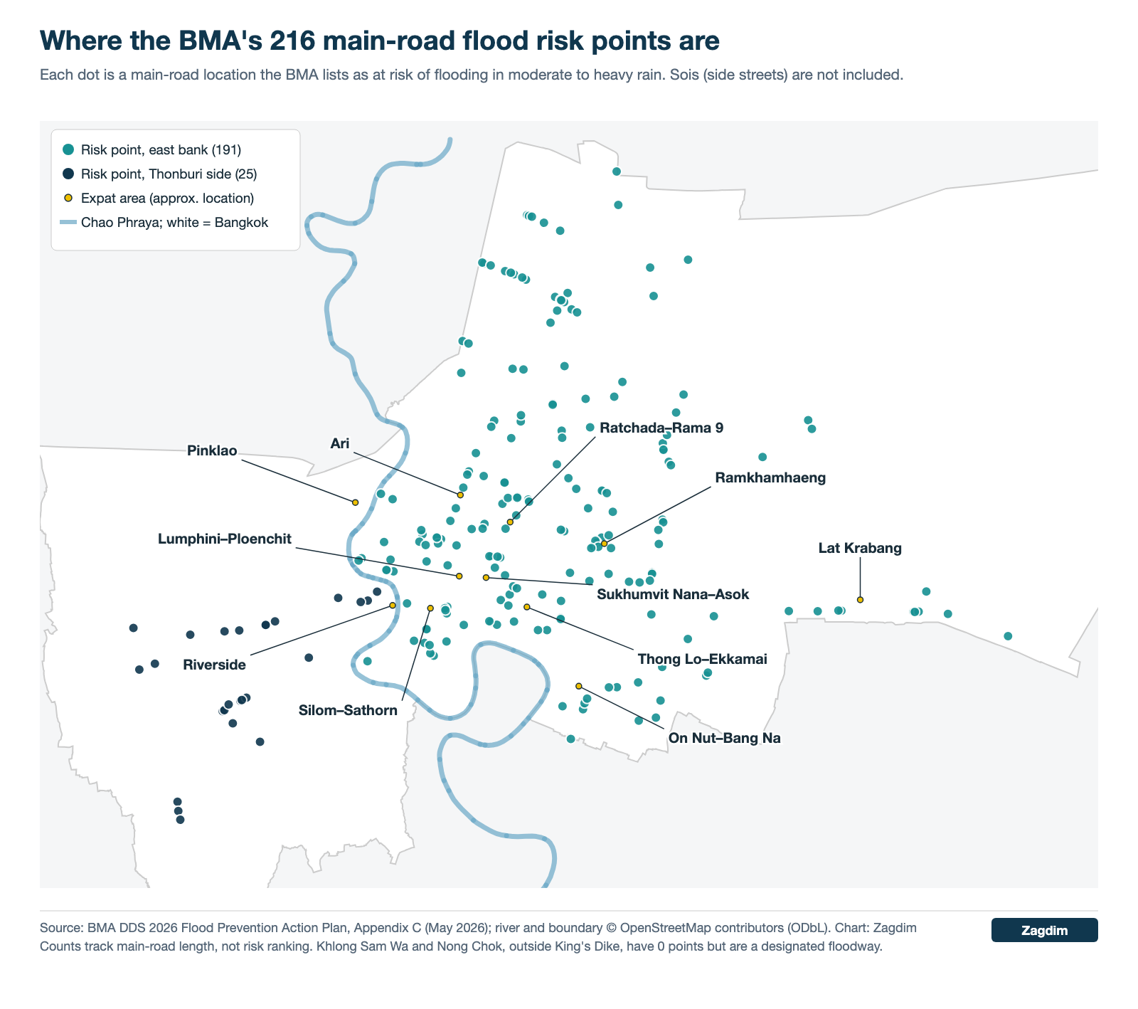
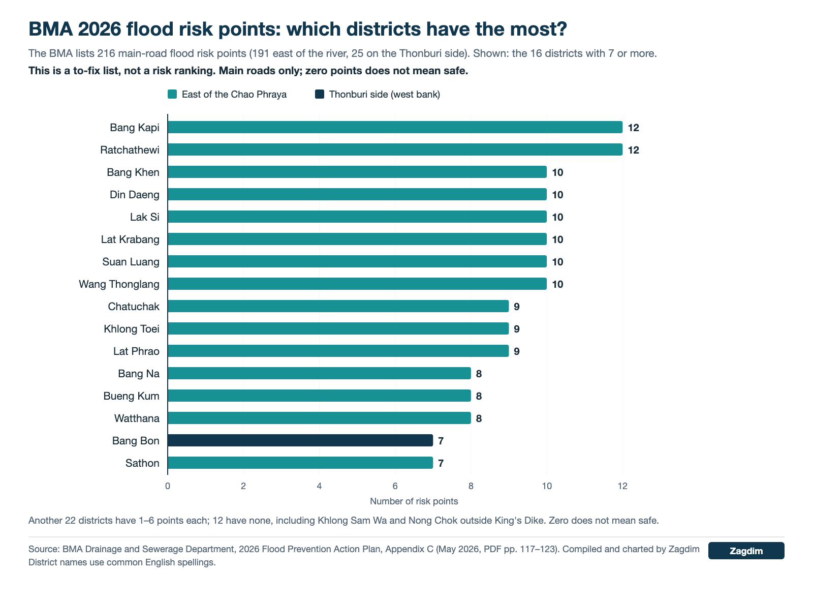
In an appendix to its 2026 flood plan, the BMA lists 216 flood risk points on main roads, drawing on lessons from 2025. They are defined as “locations at risk of flooding in moderate to heavy rain”: 191 east of the river and 25 on the Thonburi side. The district groupings below are taken from that appendix (PDF pp. 117–123); the per-district counts were compiled by Zagdim:
| Risk points | Districts |
|---|---|
| 12 | Bang Kapi, Ratchathewi |
| 10 | Lak Si, Bang Khen, Din Daeng, Wang Thonglang, Suan Luang, Lat Krabang |
| 9 | Chatuchak, Lat Phrao, Khlong Toei |
| 8 | Watthana, Bang Na, Bueng Kum |
| 7 | Sathon, Bang Bon |
| 5–6 | Phaya Thai, Prawet, Don Mueang, Bang Khae |
| 3–4 | Sai Mai, Huai Khwang, Phasi Charoen, Bang Khun Thian, Phra Nakhon, Samphanthawong, Bang Kho Laem, Yan Nawa, Khlong San |
| 1–2 | Dusit, Pathum Wan, Bang Rak, Phra Khanong, Min Buri, Pom Prap Sattru Phai, Khan Na Yao, Chom Thong, Bangkok Yai |
| 0 | Bang Sue, Saphan Sung, Khlong Sam Wa, Nong Chok, Thung Khru, Rat Burana, Thon Buri, Bangkok Noi, Bang Phlat, Taling Chan, Thawi Watthana, Nong Khaem |
Examples of listed points in areas popular with expats: in Khlong Toei, the Phrom Phong station stretch of Sukhumvit Road, Sukhumvit Soi 22 and Soi 26; in Watthana, Soi Phrom Chai, Soi Phrom Mit, Sukhumvit Soi 31 and the Ekkamai Road junction; in Sathon, the whole of Suan Phlu and Sathon Soi 11; in Bang Rak, Sala Daeng Soi 1/1.
Keep four things in mind when reading the list:
- It covers main roads only, not sois.
- It is the BMA’s list of places to fix, not a risk ranking.
- The number of points depends on the length and density of main roads in each district.
- Zero points does not mean safe: Khlong Sam Wa and Nong Chok, outside King’s Dike, both have zero points but are part of the BMA’s designated floodway.
Before You Rent or Buy in Bangkok: A Flood Checklist for the Building
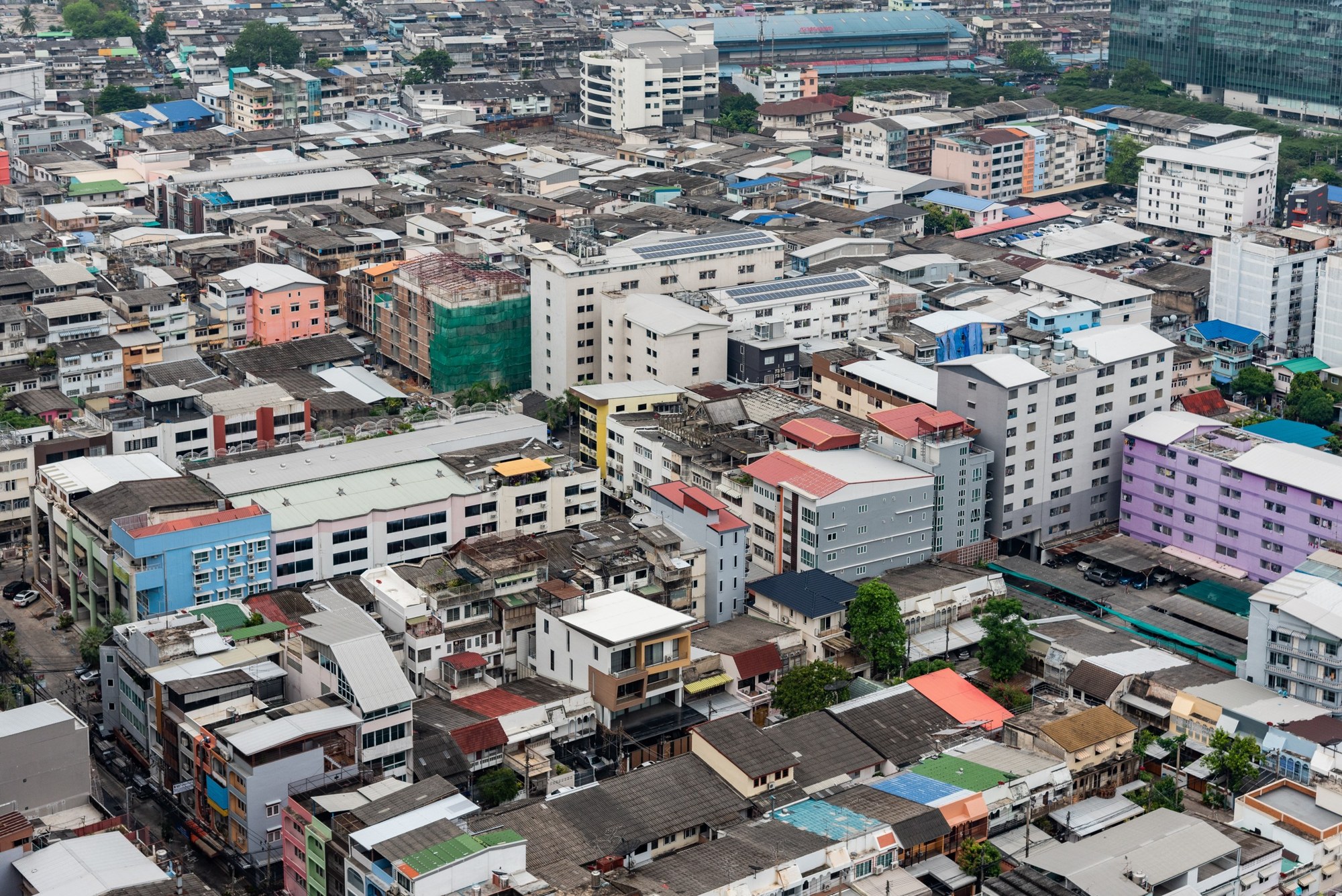
Renting: What to Check at the Viewing
- Floor: choose a unit on the second floor or higher; ground-floor and semi-basement units are the most exposed.
- How low the soi is: the BMA plan notes that sois are often lower than main roads. Visit once during or after rain and look for signs of standing water between the mouth of the soi and the entrance.
- Car park: if you have a car, ask whether parking is below ground or above it; when an underground car park floods, both cars and lifts are affected.
- Access road: check whether the road between the condo and the rail station is on the BMA’s list of 216 risk points.
- Distance to rail: the BTS and MRT ran normally on 24–26 September 2026, so a unit within walking distance of an elevated station may mean less disruption to your commute when roads flood.
- Ask the juristic person: ask the building’s juristic person (the condominium management body, นิติบุคคล in Thai) whether the lobby, car park or lifts have taken in water in heavy rain in recent years, and where the pumps are.
- The lease: under Sections 546 and 550 of the Thai Civil and Commercial Code, the landlord must hand over the property in good condition, and necessary repairs during the lease are in principle the landlord’s responsibility; if a defect is serious and the landlord does not deal with it within a reasonable time, the tenant may terminate the lease under Section 551. It is clearer to write into the lease how flooding will be handled before you sign.
- Your own insurance: the building’s common-area policy does not necessarily cover furniture and personal belongings inside your unit, so check what your own policy covers.
Buying: Extra Checks
- What is in the basement: besides parking, ask whether the electrical room, water pumps and generator are below ground. If this equipment takes in water, the whole building stops working.
- The juristic person’s insurance: Thailand’s Condominium Act does not require common areas to be insured; whether they are is decided by each building’s regulations or the co-owners’ meeting. Ask the juristic person for the policy details before you buy.
- The natural-disaster limit on home fire insurance: Thailand’s standard home fire insurance already includes cover for windstorm, flood, earthquake and hail, but the combined limit for all four is THB 20,000 a year. For higher cover you need to add a natural-disaster endorsement (อค.1.35), and ask the insurer whether high tides and river water backing up are covered.
- No duty to disclose flood history: we found no Thai regulation requiring a seller or landlord to disclose flood history. Section 472 of the Civil and Commercial Code makes the seller liable for defects, but the exceptions in Section 473 include a defect the buyer “should have known of by exercising the care of an ordinary person”; because the BMA publishes its risk data, this could be argued. For details, consult a Thai lawyer.
- Riverside property: confirm the building is inside the flood wall, and find out which access routes you would use during the October–December high-water period.
- Property outside King’s Dike: in the floodway area, such as Lat Krabang and Nong Chok, factor in the possibility of prolonged standing water from October to December.
- Off-plan or new projects: check the developer’s finances and building permits separately.
How to Check a Bangkok Address Yourself
The tools below are run by the BMA, its Drainage and Sewerage Department, or Thai government agencies and platforms working with the BMA:
| Tool | What you can check | How to use it |
|---|---|---|
| BMA Flood Risk Data Platform | Map of risk points (filter by district), road flood sensors, rainfall, residents’ flood complaints | Web dashboard, no login needed; not confirmed to be real-time |
| BMA Drainage and Sewerage Department live sensors | Road water levels and rainfall by station | Website |
| Traffy Fondue | Residents’ reports and the BMA’s progress in handling them; shows whether there are flood complaints nearby | LINE official account @traffyfondue, or the website |
| BMA hotline 1555 | 24-hour reporting and help | Phone |
| Thai Meteorological Department hotline 1182 | Weather forecasts | Phone |
| BMA 2026 Flood Prevention Action Plan | Appendix of 216 risk points, King’s Dike map | PDF of about 161 MB, a very large file |
Links to all of these are in the References at the end of this article.
Condos That Meet Public Flood Criteria: 11 Bangkok Examples
The 11 buildings below are examples Zagdim selected using public data. They are not recommendations to buy or rent. Zagdim and ZDelp have no commercial relationship with these developments, their developers or the listing platforms. The criteria were:
- Parking is above ground level (no underground parking level found in public data; exceptions are noted).
- The nearest BMA risk point is roughly 300 m or more away, and the access road was not on the 24–26 September 2026 road-closure lists.
- Within walking distance of the elevated BTS, MRT or Gold Line (exceptions are noted).
- Riverside properties must be inside the flood wall.
- Within the scope of our public searches, no reports were found of the building flooding in 2011 or in September 2026.
Zagdim did not visit these buildings. Parking levels are based on public data, and for some buildings it is still unconfirmed whether there is an additional basement level (see notes). Finding no flood reports does not mean a building has never flooded, and does not mean it will not flood in future.
Sources: parking type is drawn from Thai property review websites and the Treasury Department’s condominium appraisal tables; prices and rents come from the Thai property data site Realist and the listing platform ZmyHome; distances to risk points are straight-line distances Zagdim calculated from coordinates, not walking distances. Compiled on 26 September 2026; dates of price data are in brackets:
| Condo | Area | Nearest rail station and distance | Parking | Distance to nearest BMA risk point | Price / rent reference | Notes |
|---|---|---|---|---|---|---|
| Life One Wireless | Lumphini / Ploenchit (Wireless Road) | BTS Ploenchit, about 600 m (elevated) | Floors 1–9, above ground | About 1.0 km (Nikhom Makkasan Road junction) | Resale average about THB 199,000/m² (Sep 2026); listed rents THB 16,000–35,000 (Nov 2025) | Flooding reported on 26 September 2026 on New Phetchaburi Road north-east of the building; not the building’s access road |
| Edge Sukhumvit 23 | Nana–Asok (Sukhumvit Soi 23) | BTS Asok / MRT Sukhumvit, about 250 m | Separate 9-storey car park building | About 570 m (mouth of Sukhumvit Soi 31) | Listed rents THB 18,000–65,000 (Apr 2026); no 2026 sale price data | — |
| 15 Sukhumvit Residences | Nana–Asok (around Sukhumvit Soi 13/15) | BTS Nana, about 400 m | Treasury Department appraisal lists floors 3–5 as parking | About 470 m (Asok Montri Road) | Resale average about THB 120,000/m² (Sep 2026); listed rents THB 18,000–55,000 (Jul 2025) | Whether there is also a basement parking level could not be confirmed; ask at the viewing |
| Ashton Chula-Silom | Sam Yan / Rama 4 | MRT Sam Yan, about 180 m (underground station) | Ground level and floors 1–6 | About 1.0 km (Suan Phlu) | About THB 250,000/m² (Aug 2024) | Nearest station is underground; whether the motorcycle parking area is below ground level could not be confirmed |
| Supalai Elite Surawong | Silom / Surawong (Naret Road) | MRT Sam Yan, about 850 m (underground station) | Floors 1–6, above ground | About 770 m (Surawong Road under the expressway) | Resale average about THB 152,000/m² (Sep 2026); listed rents THB 25,000–30,000 (2024) | Nearest station is underground; rent data is older |
| Menam Residences | Riverside, Charoen Krung (east bank, inside the flood wall) | BTS Saphan Taksin, about 1.6 km | Car park below the 10th-floor podium, above ground | About 1.4 km (Charoen Krung Road at Thanon Tok) | Treasury appraisal THB 94,000–128,400/m² (Aug 2024); listed rents for larger units THB 52,800–55,000 (Sep 2026) | Not within walking distance of rail; the southern part of Charoen Krung Road, the access road, has flooded during past high-water periods, so check access in October–December |
| Magnolias Waterfront Residences | Riverside, Khlong San (west bank, next to ICONSIAM) | Gold Line Charoen Nakhon station, about an 8-minute walk (elevated) | Floors 1–5 | About 760 m (Surawong, across the river); nearest on the same bank about 1.0 km | Two-bedroom listings THB 33.1–55.8 million (Sep 2026) | Residents’ basement parking could not be ruled out; the BMA aims only to “mitigate” on the west bank; Charoen Nakhon Road, the access road, flooded in September 2025 |
| Urbano Absolute Sathon-Taksin | Khlong San (Charoen Nakhon Soi 14/2, not on the river) | BTS / Gold Line Krung Thon Buri, about 320–400 m (elevated) | Floors 3–9 plus open-air parking | About 1.2 km | Treasury appraisal THB 73,600–93,100/m² (Aug 2024); one-bedroom 38 m² listed from THB 20,000 a month (Sep 2026) | One-way soi; Charoen Nakhon Road flooded in September 2025 |
| Ideo Sukhumvit 93 | On Nut–Bang Na (Bang Chak) | BTS Bang Chak, about 90–240 m (elevated) | Podium floors 1–4 plus ground level | About 2.3 km (Sukhumvit Road, Udom Suk section) | Treasury appraisal THB 101,200–130,300/m² (Aug 2024); listed rents THB 12,000–35,000 (Sep 2026) | A main road in the area was listed as a road to avoid in September 2026; at the viewing, check the Sukhumvit side lane outside the building |
| Ideo Mobi Sukhumvit (Soi 81) | On Nut | BTS On Nut, about 200 m (elevated) | Separate car park building plus open-air parking; a review says the site is about 60 cm higher than Sukhumvit Road | About 1.7 km | Treasury appraisal THB 100,500–126,400/m² (Aug 2024); listed rents THB 10,500–55,000 (Sep 2026) | Nearby On Nut Road (Sukhumvit 77) was listed as a flooded road in September 2026; it is a different road from the Sukhumvit Road side of the building |
| Life Pinklao | Pinklao (Bang Phlat, not in the riverbank strip) | MRT Bang Yi Khan, about 100 m (elevated) | 4 floors inside the building, above ground | More than 2 km (the district has 0 listed points, which may understate risk) | Treasury appraisal THB 91,000–110,200/m² (Aug 2024); listed rents THB 13,000–16,000, sale prices THB 3.45–4.6 million (Sep 2026) | Bang Phlat was on the BMA evacuation list in 2011; few reports from the Thonburi side in September 2026 |
Treasury Department appraisals are usually below market prices and are only a guide to the price band; listed rents cover different unit types, so ask separately about actual transaction prices.
Common Misunderstandings About Bangkok Flooding
Misunderstanding one: Thonburi as a whole is higher ground, so living west of the river is safer.
The higher ground described in the BMA plan is the strip along the Chao Phraya, not the whole of Thonburi. On the BMA’s 2011 evacuation list, Bang Phlat, Thawi Watthana and Taling Chan were all on the Thonburi side, and Bang Khae was named as needing close monitoring. The BMA’s objective for the Thonburi zone is also only to “mitigate”, not to “protect”. In practice: west of the river, only look at the stretch close to the river and inside the flood wall.
Misunderstanding two: a district with zero points on the risk list is a safe district.
The list only counts main roads, and it is a list of places to fix. Khlong Sam Wa and Nong Chok, outside King’s Dike, both have zero points but are part of the floodway the BMA deliberately keeps. In practice: read zero points together with elevation and flood defences.
Misunderstanding three: once the rain stops, the flood season is over for the year.
The BMA plan records that water from the north brings the Chao Phraya to its highest level in October–November, and tides peak in October–December. In practice: for riverside property and property outside King’s Dike, look at October to December, not just September.
Misunderstanding four: living on a high floor means you are not affected at all.
Water will not reach a high-floor unit, but the underground car park, electrical room, lifts and access roads can all be affected. In practice: at the viewing, check the shared facilities and the way in and out as well.
Misunderstanding five: if you have home fire insurance, all flood damage is covered.
The natural-disaster cover in standard home fire insurance has a combined limit of THB 20,000 a year for four perils; in the policy wording, “flood” means water entering the building from outside, and the ordinary “water damage” clause does not cover external flooding. In practice: add a natural-disaster endorsement if you need it, and check each item.
Choosing a Bangkok Neighbourhood: Three Scenarios
Scenario one: a professional posted to Bangkok, renting for a year.
The office is around Asok and they have no car. Start with condos in the Nana–Asok stretch within walking distance of the BTS or MRT, on the second floor or higher, where the mouth of the soi is not on the risk list. In the first month of the wet season, keep an eye on nearby flood complaints on Traffy Fondue, and make sure the lease states who is responsible for repairs after a flood.
Scenario two: buying a Bangkok condo to live in and rent out.
With a mid-range budget, they are considering the inner city and the On Nut area. Lumphini and Nana–Asok in the inner city show fewer public warning signs. On Nut is cheaper, but some roads flooded in September 2026, so check each building’s parking, podium height and soi. Before buying, ask the juristic person for the common-area policy and records from recent heavy rain, and check the natural-disaster limit on your own home fire insurance.
Scenario three: a retiree who wants a river-view condo for a long stay.
The riverbank is higher ground, but confirm that the building is inside the flood wall and whether the access roads are affected during the October–December high-water period. The BMA’s flood-protection objectives differ between the east and west banks, so include that in the comparison.
FAQ: Bangkok Flood Risk, Renting and Buying
Which areas are worst hit by Bangkok flooding?
The BMA does not publish a ranking of “most dangerous districts”. From official data, the lowest ground is in the east, centre and south (0 to 0.5 m, with the Ramkhamhaeng University area below sea level); the districts with the most main-road risk points are Bang Kapi and Ratchathewi (12 each); and Lat Krabang, Nong Chok and other areas outside King’s Dike are the BMA’s designated floodway. The actual impact still depends on the soi and the building.
Can I still use the BTS and MRT during a Bangkok flood?
According to a Tourism Authority of Thailand notice on 26 September 2026, the BTS, the MRT Blue, Purple, Yellow and Pink lines and the Airport Rail Link all ran normally on 24–26 September, while many roads were closed. Elevated rail is not directly affected by water on the road, but the walk from home to the station may flood, so check the access road when choosing a home.
Is Thonburi less affected by Bangkok floods?
Not necessarily. The higher ground is the riverbank strip along the Chao Phraya; outer Thonburi was badly hit in 2011, and Bang Phlat, Thawi Watthana and Taling Chan were all on the BMA evacuation list. The BMA’s objective for the Thonburi zone is to “mitigate”, not to “protect”. Thonburi has fewer risk points partly because it has fewer main roads, not because it is safer.
If my Bangkok rental floods, who pays for repairs?
Under the hire-of-property rules in the Thai Civil and Commercial Code, the landlord must hand over the property in good condition, and necessary repairs during the lease are in principle the landlord’s responsibility, while the tenant is only responsible for routine upkeep and minor repairs. If a defect is serious and the landlord does not deal with it within a reasonable time after being notified, the tenant can terminate the lease. The actual position depends on the lease terms, so it is best to write down how flooding will be handled when you sign.
Does a seller in Bangkok have to disclose past flooding?
We found no Thai regulation requiring disclosure of flood history. The Civil and Commercial Code makes the seller liable for defects, but a defect the buyer “should have known of” may be an exception, and the BMA already publishes its risk-point and elevation data. We found no case law on whether flooding once counts as a defect, so check the address yourself and ask the juristic person before buying, and consult a Thai lawyer if needed.
How much Bangkok flood damage does home fire insurance cover?
Thailand’s standard home fire insurance already includes four natural-disaster perils (windstorm, flood, earthquake and hail), with a combined limit of THB 20,000 a year, paid on actual loss. You can raise the cover by adding a natural-disaster endorsement, and flood can be given its own sum insured and deductible. Premiums and limits vary by insurer.
Renting or Buying in Bangkok? Ask Zagdim
If you want to know how to read the public data for a Bangkok address or condo building, Ask Zagdim.
Life abroad? Ask Zagdim.
Your first stop for international property and global living.
Research and insights. Know what’s changing. Understand what matters.
Newsletter for overseas updatesSubscribe →
Important Disclaimer
This article is general information and does not constitute legal, tax, financial or insurance advice, nor a recommendation to buy or rent any development. The condos listed are only examples that meet public criteria; Zagdim has not visited or tested individual buildings, and finding no flood reports does not mean a building has never flooded, nor that it will not flood in future. The information is mainly based on the BMA’s flood plan of May 2026, BMA notices from 2011, official notices and Thai media reports from 24–26 September 2026, and public data from Thai property websites. Rules and conditions may change. Before renting or buying, check the address yourself, view the property in person, and consult a qualified Thai lawyer or insurance professional where necessary.
Rules and data current as of 26 September 2026; refer to the Bangkok Metropolitan Administration and Thai government for the latest official position.
Appendix: How the Areas Were Rated and the Condos Selected
Which areas were compared: 12 areas that are common choices for foreign renters and buyers, most within walking distance of a rail station; this is not a random sample. Rail access was only used to choose which areas to compare and was not scored.
Five indicators, each scored 0–2:
- Elevation: based on the zone-level elevation description in the BMA flood plan. Riverbank strip and north (about +1.5 m): 2 points; centre, east and south (0 to +0.5 m): 1 point; the Ramkhamhaeng University area, which the BMA names as below sea level: 0 points. This is a zone-level description, not street-by-street elevation.
- Flood defences: inside King’s Dike and inside the flood wall (BMA objective: “protect”): 2 points; the Thonburi zone (objective only to “mitigate”), riverside areas with some communities outside the wall, or areas not wholly within BMA jurisdiction: 1 point; the floodway outside King’s Dike: 0 points.
- Risk points: the number of BMA risk points within a 1 km straight-line radius of the area’s main rail station; a point within range of more than one station is counted once. 0–2 points: 2; 3–6: 1; 7 or more: 0. Station coordinates are approximate. Bang Kapi / Ramkhamhaeng does not yet have an operating rail station, so Ramkhamhaeng University was used as the centre. The list only covers main roads, so districts with few main roads will score low counts. The riverside was calculated separately for each bank: the east bank centred on BTS Saphan Taksin, and the west bank on the Gold Line’s Charoen Nakhon and Khlong San stations; straight-line distance can reach points on the opposite bank.
- The 2011 floods: the district classification comes from data republished by Thai property media in January 2012 and attributed to the BMA; Zagdim could not locate the original BMA document. Classed as not flooded: 2 points; river briefly rising or less than 20% affected: 1 point; more than 20% affected or the whole district flooded for a long period: 0 points. Where an area spans two districts, the lower score is used.
- 24–26 September 2026: BMA small-vehicle closures or clear reports of deep water: 0 points; marginal sensor readings, media mentions or too little reporting: 1 point; no mention in BMA notices or mainstream Thai media: 2 points.
Tier thresholds: a total of 7 or more, with no 0 score in either the 2011 or the September 2026 indicator, is “recommended”; 5–6, or 7 or more with a 0 in one of those two indicators, is “consider with inspection”; 4 or below is “extra caution”. Those two indicators have their own threshold because they record actual flooding. The thresholds were set by Zagdim for this research and have not been calibrated against historical data.
Condo selection: starting from developments frequently mentioned in each area, we checked each building’s parking levels, straight-line distance to BMA risk points, nearest rail station, and flood reports from 2011 and September 2026 (Thai- and English-language web searches, plus the BMA and media road-closure lists for that week). Buildings meeting all criteria are listed; those missing one criterion are also listed, with the gap noted. Buildings with underground parking, with parking type unknown, or too close to a risk point are not listed. Not being listed does not mean a building has flooded. Building coordinates are taken from OpenStreetMap or review websites; a few are estimated.
References
Bangkok Metropolitan Administration Drainage and Sewerage Department – 2026 (B.E. 2569) Flood Prevention Action Plan (PDF, in Thai) / Bangkok Metropolitan Administration Drainage and Sewerage Department – Plan documents download page (in Thai) / Bangkok Metropolitan Administration – Flood Risk Data Platform / Bangkok Metropolitan Administration Drainage and Sewerage Department – Real-time road flooding and rainfall sensors / Traffy Fondue – Citizen reporting platform / Thai Meteorological Department – Home page / Royal Irrigation Department – Daily water situation report (PDF, in Thai) / Tourism Authority of Thailand – Weather and travel conditions in Bangkok and surrounding areas / Thai PBS – All 50 Bangkok districts declared disaster zones (in Thai) / The Standard – Bangkok’s 50 disaster-zone districts and how to apply for relief (in Thai) / The Reporters – Bangkok governor’s press conference (in Thai) / The Nation – Bangkok 24-hour rainfall by station / The Nation – Bangkok roads closed to small vehicles / Thai PBS – Bangkok road water-level sensor readings (in Thai) / spacebar – Chao Phraya flow forecast (in Thai) / Asia News Network – Bangkok on alert as high tides threaten 11 riverside communities / ReliefWeb – Announcement of Bangkok Metropolitan Administration, 31 Oct 2011 / ReliefWeb – Announcement on flooding situation in Bangkok, 8 Nov 2011 / FM91 Trafficpro – Charoen Nakhon Road flooding report, 4 September 2025 (Facebook, in Thai) / Matichon – Overflow and road collapse on Charoen Krung Road at Thanon Tok, September 2025 (in Thai) / M Plus Home – How Bangkok’s 50 districts were affected by the 2011 floods (in Thai) / Groundwater – Soonthornrangsan, Bakker & Vossepoel (2024), land subsidence in Bangkok / Legardy – Thai Civil and Commercial Code, Section 472 / Legardy – Thai Civil and Commercial Code, Section 473 / Thailand Law Online – Thai Civil and Commercial Code, hire of property (Sections 537–571) / Department of Lands – Condominium Act, consolidated text (PDF, in Thai) / Bangkok Insurance – Standard home fire insurance policy wording (PDF, in Thai) / Realist – Life One Wireless / Realist – Supalai Elite Surawong / Realist – 15 Sukhumvit Residences / ZmyHome – Edge Sukhumvit 23 / ZmyHome – Menam Residences / homenayoo – Edge Sukhumvit 23 / homenayoo – Ashton Chula-Silom / condonayoo – Supalai Elite Surawong / PropertyScout – Magnolias Waterfront Residences